

In 700 BCE, the Assyrian king Sennacherib ordered the construction of a canal system to bring water from the mountains of northern Iraq to his new capital at Nineveh. The project required cutting through solid basalt, spanning ravines on stone arches, and sustaining a gradient precise enough to move water roughly 80 kilometers without a pump. When it worked, the gardens of Nineveh bloomed in a region that otherwise received fewer than 300 millimeters of rain per year. That single project captures what ancient infrastructure actually was: not monumental architecture performed for prestige, but the hard technical work of making a settlement viable where nature did not make it easy. Roads, aqueducts, harbors, drainage systems, and standardized weights were not luxuries. They were the mechanisms through which states turned territory into functioning economies and populations into tax-paying subjects. This post examines how several of the ancient world’s most significant infrastructure systems were actually built, maintained, and paid for, and what happens to political power when those systems stop working.
Water Management: The Oldest and Most Critical Technology
Fresh water management was the first large-scale engineering problem that ancient states had to solve, and the solutions they developed reflect every dimension of their political and environmental situations. In river valley civilizations the challenge was not finding water but controlling it: preventing catastrophic floods in wet seasons while storing enough to irrigate through dry ones. In arid regions the challenge was supply: finding, moving, and preserving water against evaporation and contamination across distances that made most settlement seem impossible. Andrew Wilson of the University of Oxford, writing in the Oxford Handbook of Engineering and Technology in the Classical World, has emphasized that the Roman engineering achievement in water supply, which he estimates delivered between 500 and 1,500 liters per person per day in major cities by the 2nd century CE, depended not on spectacular innovation but on the systematic application of well-understood principles: gravity flow, sealed pipes, settling tanks, and regular maintenance contracts.
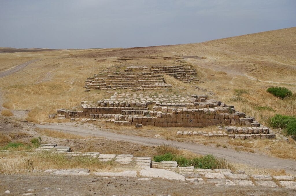
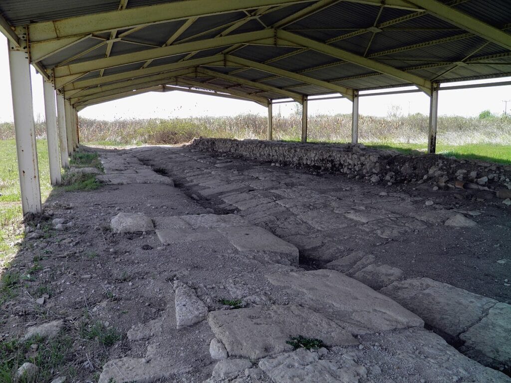
The Jerwan aqueduct, excavated by Thorkild Jacobsen and Seton Lloyd for the Oriental Institute of the University of Chicago in the 1930s, is the oldest known stone arched aqueduct in the world. It carried water across the Gomel river valley on five pointed arches, each approximately 3 meters wide, constructed from precisely dressed limestone blocks set in waterproof bitumen mortar. Sennacherib’s royal inscriptions, preserved on stone slabs found at the site, describe the project in terms that modern engineers would recognize: he ordered his provincial governors to conscript workers from across his territory, staged materials at collection points along the route, and used cuneiform tablets to track the volume of water delivered to Nineveh against projected targets. The explicit connection between water supply, agricultural productivity, and royal legitimacy in those inscriptions is not propaganda in the modern sense. It was an accurate description of how Assyrian state power worked: the king who kept the water flowing kept his subjects loyal.
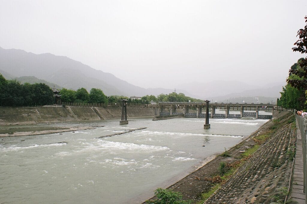
In Sichuan, China, a different engineering philosophy produced an equally durable result. The Dujiangyan irrigation system, begun by Li Bing as governor of Shu under the Qin state around 256 BCE and still in operation today, diverts the Min River without a dam by using a fish-mouth levee to split the flow into an inner canal for irrigation and an outer channel that handles seasonal flood discharge. The genius of the design is that it uses the river’s own centrifugal force, which pushes heavier silt toward the outer bank at a bend, to keep the inner irrigation canal relatively clean without mechanical intervention. Li Bing’s son subsequently deepened a bottle-neck channel through solid rock using a technique of alternating fire and water to crack the stone, producing a controlled flow reduction that maintained appropriate water pressure in the irrigation system during high flood years. UNESCO’s World Heritage designation of the site in 2000 noted that the system has irrigated the Chengdu plain for over two thousand years with minimal structural alteration, a maintenance record unmatched by any large dam built in the 20th century.
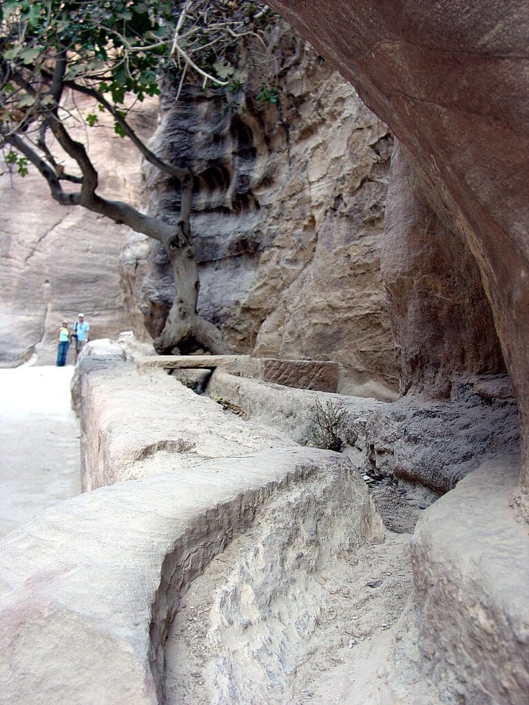
Petra’s water system demonstrates what the Nabataeans achieved in a desert canyon receiving roughly 100 millimeters of rainfall annually. Archaeologists surveying the site between 1993 and 2003, led by Judith McKenzie of the University of Oxford, documented a network of rock-cut channels, ceramic pipe sections, and plastered settling cisterns that collected flash-flood runoff from the surrounding mountains and directed it through the Siq, Petra’s narrow entrance canyon, into a series of reservoirs within the city. The channels were cut at a gradient of roughly 1 in 200, shallow enough to prevent erosion but steep enough to maintain flow velocity against silt accumulation. Overflow outlets were cut at regular intervals to prevent the channels from being overwhelmed during extreme rainfall events. The system could supply approximately 30,000 cubic meters of water annually, enough for a city population estimated at between 20,000 and 30,000 people, entirely from collected rainfall with no perennial river source whatsoever.
Roads and the Mechanics of Overland Movement
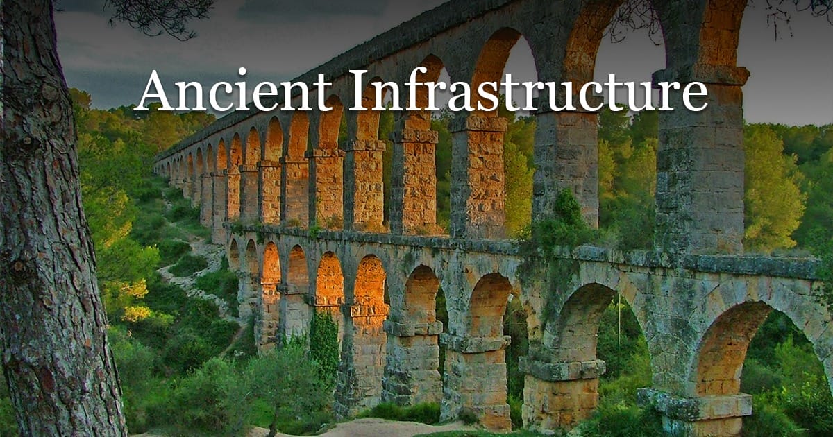
The Roman road network covered roughly 80,000 kilometers of primary roads by the 2nd century CE, connecting every major military garrison, provincial capital, and commercial port in a territory stretching from Hadrian’s Wall in northern Britain to the Euphrates frontier. The technical achievement is real, but its political function is what made it transformative. Fergus Millar, formerly Camden Professor of Ancient History at the University of Oxford, argued that the Roman Empire was in a meaningful sense constituted by its road system: without the ability to move legions, dispatches, and tax revenues across enormous distances in predictable time frames, the administrative fiction of a unified empire could not have been maintained. Speed was not the primary engineering goal. Reliability was. A Roman military road was built to carry loaded wagons in all weathers, which meant raised foundations, cambered surfaces to shed rainwater, flanking drainage ditches, culverts at stream crossings, and retaining walls wherever a road cut through unstable slopes.
The Via Egnatia, constructed beginning around 146 BCE after Rome’s annexation of Macedonia, ran approximately 1,120 kilometers from the Adriatic port of Dyrrachium (modern Durrës, Albania) across the Balkans to Byzantium on the Bosporus. It was designed to move Roman forces between Italy and the eastern provinces without the delays and dangers of sea passage. The engineering survey required crossing the Pindus mountain range at elevations exceeding 1,500 meters, the Axios and Strymon rivers (bridged with stone arches), and extensive marshy terrain near the Aegean coast (handled with raised causeways on wooden piling). Milestones were placed at intervals of one Roman mile, each bearing the distance to the nearest major city and the name of the magistrate responsible for that road section, creating both a navigation system and a public accountability mechanism. A governor whose milestones showed deterioration risked senatorial censure.
Road maintenance in the Roman system was not a central government function. It was distributed through a system of legal obligation called the munera, under which landowners along a road corridor were required to furnish labor for repairs proportional to the size of their estates. This worked imperfectly, as most distributed maintenance systems do, and the archaeological record shows multiple episodes of road repair in which new paving was simply laid over an accumulation of older surfaces without removing the debris, raising the road level by 30 to 60 centimeters above its original grade over the course of several centuries. The legal scholar Ulpian, writing in the early 3rd century CE, compiled the relevant statutes on road maintenance obligations into the Digest, demonstrating that Roman administrators regarded road upkeep as a serious enough legal question to require authoritative clarification.
Ports and Harbors: Where Land Infrastructure Met the Sea
Maritime trade carried far more bulk cargo than any road network could manage. Grain, timber, stone, and metals moved by sea because a single Roman merchant vessel of medium size, carrying perhaps 200 to 400 tons of amphorae, could deliver more cargo in a single voyage than 200 ox-carts making the same journey overland. That economic reality made harbor infrastructure a state priority of the first order. The challenge was geological and biological as much as it was engineering: harbors silt up from river discharge, marine organisms bore into wooden structures, and storms can shift harbor entrances by depositing sand bars faster than any ancient dredging crew could remove them. Successful ancient ports solved these problems not by fighting the sea but by working within its rhythms.
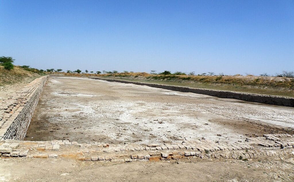
The dockyard at Lothal in Gujarat, excavated by S.R. Rao for the Archaeological Survey of India between 1955 and 1962, presents what Rao interpreted as the world’s earliest known tidal dock, dated to approximately 2400 to 1900 BCE. The structure is a trapezoidal brick-lined basin roughly 218 meters long by 36 meters wide, connected to the estuary of the Sabarmati River by an inlet channel fitted with a sluice gate mechanism. The prevailing interpretation is that incoming tidal flow would raise the basin water level and float vessels in for loading and repair, after which the sluice gate would be closed to maintain water depth as the tide receded. This prevented vessels from sitting on the mud during low water, which damages hull planking, and gave workers stable access for caulking and maintenance. Some scholars, including Jonathan Mark Kenoyer of the University of Wisconsin-Madison, have questioned whether the basin functioned as a true tidal dock or rather as a freshwater storage tank, but the precision of the brickwork, including angled inlet channels designed to reduce the velocity of incoming tidal surges, suggests a sophisticated understanding of hydraulic engineering regardless of the structure’s primary function.
Roman harbor construction at Caesarea Maritima on the coast of modern Israel, ordered by Herod the Great beginning around 22 BCE and studied intensively by the joint American-Israeli Caesarea Ancient Harbour Excavation Project from 1980 onwards, used pozzolanic concrete, a volcanic ash-based mortar that sets and hardens underwater without air exposure, to construct an artificial harbor basin in open sea where no natural shelter existed. Engineers mixed crushed volcanic tuff from the Bay of Naples with seawater and lime to produce a concrete that gained structural strength as it cured, pouring it into timber form-work lowered from barges to form the foundations of two enormous breakwaters. The inner harbor created by these structures covered approximately 100,000 square meters, sufficient to shelter 300 vessels simultaneously. The use of underwater concrete at this scale was not equalled until the 19th century CE.
Built out of a love for history, kept free from distractions.
Spoken Past is an independent project shaped by curiosity, care, and long hours of research. Reader support helps keep it maintained, carefully researched, and open to everyone.
Sanitation and Drainage: The Infrastructure Nobody Celebrates
The ancient world’s sanitation infrastructure is the least celebrated and arguably the most consequential of all its engineering achievements. Cities without adequate drainage become breeding grounds for typhoid, dysentery, and cholera within a few decades of reaching dense population levels. The correlation between investment in underground drainage and the duration of urban settlement is not accidental: cities that maintained their drains survived; cities that did not were periodically devastated by epidemic disease that reduced their populations and economic productivity sufficiently to make them vulnerable to conquest or abandonment.
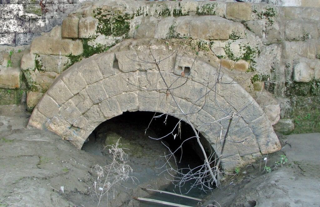
Rome’s Cloaca Maxima, the great sewer, began as an open drainage channel for the Forum valley, probably in the 6th century BCE. Over the following centuries it was vaulted with stone arches, extended through the city’s major neighborhoods, and ultimately carried combined stormwater and waste from approximately a million people into the Tiber. The section of the drain visible today near the Forum Boarium, dated to the late 2nd century BCE, is built from four concentric rings of volcanic tuff ashlar, each ring approximately 60 centimeters thick, spanning a channel roughly 3.2 meters wide. The engineering allowed maintenance crews to enter from manhole openings in the street above, work inside the drain during dry periods, and clear blockages without disrupting surface traffic. Modern sewer engineers use essentially the same design logic. The Cloaca Maxima remained in partial use until the 19th century CE, which is a maintenance record of approximately 2,500 years.
The Indus Valley cities of Mohenjo-daro and Harappa, occupied roughly between 2500 and 1700 BCE and excavated extensively since the 1920s, had drainage systems that connected individual house bathrooms to street-level drains through brick-lined chutes in the external walls. The street drains were covered with removable stone or brick slabs, allowing inspection and cleaning without disrupting pedestrian movement. The standardization of brick sizes across Indus Valley sites, with ratios consistently maintained at 1:2:4 (height:width:length), suggests a degree of centralized planning that extended to drainage infrastructure: you cannot connect a house drain to a street drain efficiently if their dimensions are inconsistent. Who administered that standardization, and how, remains one of the unresolved questions of Indus Valley archaeology.
Standards, Materials, and the Economics of Building
Ancient infrastructure did not emerge from unlimited budgets. Every major project involved choices about materials, labor, and maintenance costs that reflected specific economic and political constraints. The Romans’ mastery of pozzolanic concrete, derived from volcanic ash deposits at Pozzuoli near Naples and at Santorin in the Aegean, gave them a material that was simultaneously cheaper than dressed stone, more resistant to seismic movement due to its slight flexibility when cured, and capable of being used underwater and in situations where cut stone was impractical. The substitution of concrete for stone in foundations, walls, and vault construction during the 1st century BCE allowed Roman builders to construct structures of unprecedented scale using less skilled labor than stone masonry required, which made major public building projects more financially viable for provincial towns that could not afford the fees of master stone-cutters.
Maintenance economics were as important as construction economics. The historical record, from Mesopotamian administrative tablets through Roman legal texts, consistently shows that societies that allocated regular maintenance budgets for roads, aqueducts, and harbors spent far less total money over time than societies that allowed infrastructure to deteriorate and then funded emergency reconstruction. The Roman practice of requiring property owners to maintain road sections adjacent to their land transferred ongoing costs off the state budget but created a collective action problem: no individual landowner had sufficient incentive to invest in repairs that would primarily benefit travelers who paid no local tax. The solution, as Ulpian’s legal compilation shows, was enforcement through the courts, with regular inspections of road condition by officials called curatores viarum who could levy fines against negligent property owners and use the proceeds to hire contractors.
Ancient Infrastructure and the Limits of Political Power
The most important lesson that the history of ancient infrastructure offers is about the relationship between physical systems and political authority. States that could build and maintain infrastructure gained measurable advantages in taxation, military projection, agricultural productivity, and urban population density over states that could not. But the relationship also ran in reverse: infrastructure was expensive to build and even more expensive to maintain, and states that overextended their building programs without establishing sustainable maintenance financing found their most impressive projects becoming their most costly liabilities within a generation of completion. The Persian Royal Road, roughly 2,700 kilometers long from Sardis to Susa, was maintained through a system of royal posting stations that provided horses, food, and accommodation for official couriers at roughly 25-kilometer intervals. The administrative cost of staffing those stations was substantial, and when Achaemenid imperial revenue declined in the 4th century BCE under military pressure from the Greeks, the posting stations were the first public services to be reduced, slowing official communication at precisely the moment when rapid information flow was most critical.
The broader pattern is consistent. Roman aqueducts fell into disrepair not because the engineering was inadequate but because the municipal budgets that had funded maintenance crews were diverted to military needs from the 3rd century CE onwards. The roads that had moved Roman legions across Europe began returning to muddy tracks within decades of the Western Empire’s administrative collapse in 476 CE, not because the roads were structurally unsound but because the institutional apparatus that maintained them, the curatores, the property-owner liability system, the legal enforcement mechanism, dissolved along with the political system that had created it. Ancient infrastructure, examined carefully, is always also an argument about governance. The physical systems tell you what a state could do. Their maintenance record tells you what a state actually prioritized when resources were scarce. The two answers are rarely the same.
Sources: Andrew Wilson, “Hydraulic Engineering and Water Supply,” in The Oxford Handbook of Engineering and Technology in the Classical World, ed. John P. Oleson (Oxford University Press, 2008); Thorkild Jacobsen and Seton Lloyd, Sennacherib’s Aqueduct at Jerwan, Oriental Institute Publications 24 (University of Chicago Press, 1935); S.R. Rao, Lothal: A Harappan Port Town (Archaeological Survey of India, 1985); Avner Raban and Kenneth Holum, eds., Caesarea Maritima: A Retrospective after Two Millennia (Brill, 1996); Judith McKenzie, The Architecture of Petra (Oxford University Press, 1990); Fergus Millar, The Roman Empire and Its Neighbours (Harvard University Press, 1981); UNESCO World Heritage listing for Dujiangyan Irrigation System, whc.unesco.org/en/list/1001.