
In 1647, the Maltese nobleman Giovanni Francesco Abela published the first detailed description of a feature that archaeologists and geomorphologists have argued about ever since. Across the exposed limestone plateaux of Malta and its sister island of Gozo, parallel grooves are cut into the bedrock in pairs. They run for varying distances, converge, split apart, and in several coastal locations simply disappear over cliff edges into the sea. Abela had no satisfying explanation for them. Neither, two centuries later, did the scholars who followed him. These features are what researchers today call Malta cart ruts, and they remain among the most contested archaeological puzzles in the central Mediterranean. Their age is disputed. Their purpose is unresolved. Their mechanism of formation has generated rival theories for nearly a hundred years. What follows is a close look at what the rock actually tells us, what the scholarship says, and where genuine uncertainty remains.
A Mystery That Has Defeated Three Centuries of Scholarship
The printed record of scholarly interest in Malta’s rock-cut tracks begins in 1918, when Captain E.G. Fenton published the first detailed field observations in the journal Man. Fenton measured, sketched, and puzzled, but reached no firm conclusion about what had made the grooves or when. The next major contribution came in 1928, when Sir Temi Zammit, then director of the Museum of Archaeology in Valletta, published “Prehistoric Cart-tracks in Malta” in Antiquity. That paper included the first aerial photographs of the sites alongside systematic measurements, and it established the basic scholarly vocabulary: paired grooves, consistent gauge, and the baffling complexity of sites where dozens of track pairs intersect. Zammit also raised the question that has never been definitively answered. The ruts appeared in bedrock with no accompanying tool marks, no inscribed borders, and no associated artifacts of the kind that might fix their date.
Subsequent generations of researchers attempted to fill that gap. H.S. Gracie, writing in Antiquity in 1954, produced the first serious attempt to map the full distribution of tracks across the island, estimating hundreds of individual track pairs at dozens of separate locations. He noted that the ruts appeared exclusively on exposed limestone surfaces where ancient soil cover had eroded away, which was itself a significant clue, though an ambiguous one. The erosion could mean the tracks were originally made on a now-vanished soil surface that later wore away to reveal the bedrock below, or it could mean the soil simply protected finished grooves until it too eroded. That ambiguity has proved almost impossible to resolve without stratigraphic evidence of the kind that rarely survives in Maltese bedrock environments.
The debate intensified in the late twentieth century as researchers brought new methods to bear. By the 1990s, archaeologists including Anthony Bonanno of the University of Malta had begun arguing for a direct connection between the tracks and the island’s extraordinary megalithic temples, which date to the period roughly between 3800 and 2500 BC, known to scholars as the Temple Period. The argument was logical on its face: those temples required vast quantities of quarried stone, and some track clusters run adjacent to confirmed quarry sites. The connection seemed elegant, but physical evidence for it at the temples themselves proved elusive, and the idea remains a hypothesis rather than a demonstrated fact.
The history of study is therefore partly a history of ideas that could not quite be confirmed. Each researcher who brought rigorous methods to the sites found them yielding partial answers and raising as many questions as they settled. That record of productive frustration is itself informative. It tells us that the ruts are deeply embedded in the geological and cultural landscape of the islands, and that no single explanation accounts for all of them across all periods.
What the Ruts Actually Look Like on the Ground
To understand the debates, it helps to be precise about the physical facts. The tracks always appear in pairs. Each individual groove has either a rounded U-shaped or a sharper V-shaped cross-section, and researchers have long disagreed about whether that distinction carries chronological meaning. Some scholars, following Zammit, argued that V-profiles indicate older, more weathered grooves while U-profiles signal later cutting, because rock surfaces tend to weather from sharp edges toward rounded ones over time. Others, including the researchers who compiled the 2007 volume The Significance of Cart-Ruts in Ancient Landscapes, contested that straightforward reading, pointing out that the local limestone varies considerably in hardness and that softer beds produce rounder profiles regardless of age.
The gauge, meaning the distance between the centerlines of the two grooves in a pair, typically falls between 110 and 140 centimeters. At the best-preserved sites this figure is remarkably consistent across otherwise unrelated track pairs, which led some researchers to conclude that a standardized vehicle width was in use across the islands. The 2022 study by Huw S. Groucutt of the Max Planck Institute for Evolutionary Anthropology examined the full morphological variability of the ruts in the Journal of Archaeological Science: Reports and found that while gauge consistency is real, it is not as uniform across the archipelago as popular accounts tend to suggest. Groucutt demonstrated that the tracks vary more widely in profile, depth, and exact gauge than the classic railway-yard analogy implies, which argues against a single vehicle type or a single historical moment of creation.
Depth is similarly variable. Most tracks are shallow, perhaps a few centimeters below the surrounding bedrock surface, but the deepest examples at the San Ġwann site reach half a meter. That is deep enough for a loaded cart axle to drag on the rock above the grooves, which is precisely the mechanism Derek Mottershead of the University of Portsmouth proposed to explain why track pairs multiply. Once a groove became too deep for a vehicle to use without its body scraping the rock between the ruts, the driver moved laterally by a few centimeters and began wearing a fresh pair. Repeated over years, that process generates the dense overlapping networks visible at the most famous sites.
The Major Sites Where Malta Cart Ruts Are Still Visible
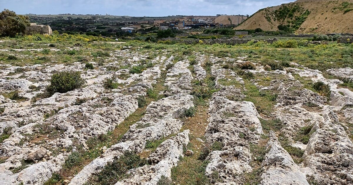
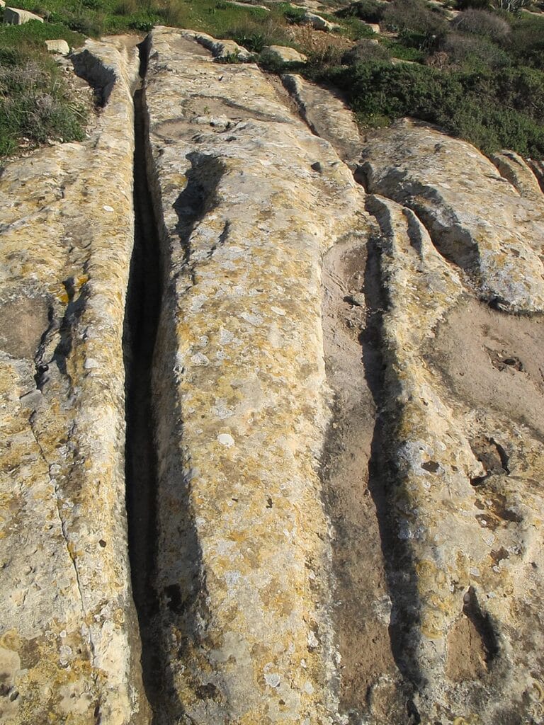
The single most impressive concentration of tracks in the archipelago lies at Misraħ Għar il-Kbir, a plateau site near the Dingli Cliffs in the municipality of Siġġiewi in the south of the main island. The site was given the English nickname “Clapham Junction” by archaeologist David H. Trump, who felt its tangled convergence of track pairs evoked the famously complex railway interchange in south London. The name stuck. Today the plateau is a scheduled Area of Archaeological Importance under Maltese law, formally designated in April 1998 under the planning authority’s protection framework. The ruts here reach up to 60 centimeters in depth and extend across an area of roughly 250,000 square meters, making it one of the largest concentrations of rock-cut ancient tracks anywhere in the world.
Misraħ Għar il-Kbir is not merely a field of parallel lines. The site includes ancient quarry faces, rock-cut cave dwellings that were occupied well into the early modern period, field boundaries, and prehistoric tombs. A documentation project presented at the 2005 CIPA International Symposium in Turin used a Leica HDS 2500 terrestrial laser scanner to capture three-dimensional point clouds of the rut surfaces, the first application of high-resolution scanning to the site. That survey showed how intimately the tracks are interwoven with the adjacent quarry activity, lending physical support to the idea that at least some of the grooves functioned as haulage routes for quarried stone.
Cart ruts at Misraħ Għar il-Kbir showing depth and spacing that suggest repeated heavy use. Source: Wikimedia Commons
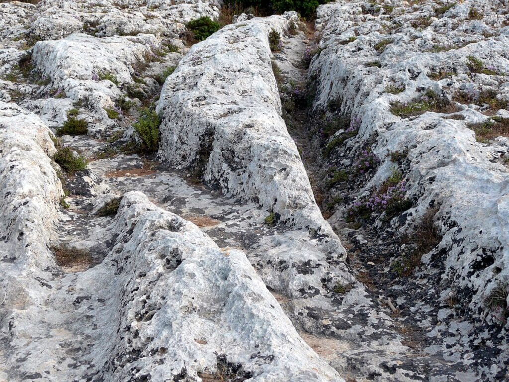
Beyond Misraħ Għar il-Kbir, the most studied sites include the Mensija tracks at San Ġwann, where a modern suburban neighborhood was built around rather than over the rock-cut grooves, leaving them exposed in gardens and beside roads. The Ta’ Ċenċ plateau on Gozo carries a set of tracks that run along the edge of a dramatic coastal cliff, their original destination unclear since the rock face drops sharply to the sea below. At the Xemxija Heritage Trail in St Paul’s Bay, a section of Punico-Roman road preserves grooves cut directly into the road surface, showing that vehicles with a similar gauge were still in use during the classical period, centuries after the tracks at Misraħ Għar il-Kbir are believed to have been formed.
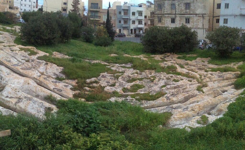
Mensija cart ruts at San Ġwann, with modern streets and walls built respectfully around the ancient grooves. Source: Wikimedia Commons
Built out of a love for history, kept free from distractions.
Spoken Past is an independent project shaped by curiosity, care, and long hours of research. Reader support helps keep it maintained, carefully researched, and open to everyone.
How the Ruts Were Formed: Three Competing Theories
The dominant explanation in current scholarship holds that the tracks were formed inadvertently by wheeled vehicles repeatedly traversing the same routes across wet limestone. Derek Mottershead, Alastair Pearson, and Martin Schaefer of the University of Portsmouth placed this hypothesis on a quantitative footing in their landmark 2008 paper published in Antiquity. They modeled the stress that a two-wheeled cart with a gauge of 1.40 meters and a moderate load would exert on the limestone under different moisture conditions. The critical finding was that the local Globigerina Limestone, the softer of Malta’s two main surface formations, loses approximately 80 percent of its compressive strength when saturated with water after winter rainfall. A cart that rolls across dry rock without leaving a mark would, on wet saturated rock, begin cutting into the surface within a relatively small number of passes. The groove then deepened progressively until it forced the driver to shift laterally, generating the parallel accumulations that characterize the busiest sites. The University of Portsmouth Research Portal holds the full citation record for this study.
This wheeled-vehicle hypothesis is the most widely cited but not the only serious contender. Claudia Sagona, in a 2004 paper in the Oxford Journal of Archaeology, proposed a fundamentally different interpretation. Sagona argued that the ruts were not accidental products of wheeled traffic at all, but were deliberately cut into the bedrock as field furrows designed to push agriculture onto marginal rocky terrain. Her reasoning drew on comparative ethnographic evidence from island farming communities elsewhere in the Mediterranean, where expanding populations under intense land pressure cut furrows directly into exposed rock to anchor soil and collect water for cultivation. Sagona also noted that some track configurations make poor sense as haulage routes but excellent sense as water channels directing rainfall toward cultivated field plots on slopes.
A third position, associated with Anthony Bonanno, interprets at least some of the ruts as purpose-built stone transport corridors connected to temple construction during the prehistoric Temple Period. The argument draws on the observation that certain track clusters originate near confirmed quarry sites and that temple building at monuments such as the Ħaġar Qim and Mnajdra complexes required moving enormous limestone blocks across difficult terrain. None of these three main hypotheses is mutually exclusive. The ruts at different sites may have had different origins, and at a single site different track pairs may reflect different activities spread across different centuries of use.
Cart ruts running along the Ta’ Ċenċ plateau on Gozo, approaching a dramatic coastal drop. Source: Wikimedia Commons
The Dating Problem: When Were the Ruts Made?
Dating the ruts has proved as difficult as explaining them, because the grooves themselves contain almost nothing that can be directly measured by radiometric methods. Limestone does not retain the organic material required for radiocarbon dating, and the ruts have yielded no sealed sediment deposits of the kind that allow pollen analysis or stratified soil chronology. Researchers have therefore relied primarily on stratigraphic relationships, identifying where ruts are cut by later features or where they cut across earlier ones.
That evidence points in several directions at once. At some sites, ruts clearly predate Roman-period features that cut across them or seal their surfaces with construction debris, establishing that those particular ruts existed before the Roman occupation of Malta beginning around 218 BC. Some researchers, noting the relationship of certain track systems to quarry sites that supplied stone for Temple Period monuments, have argued for origins as early as the Neolithic, perhaps reaching back to around 3800 BC. The physical link is suggestive but difficult to confirm without direct dating evidence.
One productive avenue has been the relationship between the ruts and the island’s changing soil cover. Mottershead and his Portsmouth colleagues, in a follow-up study published in 2010 in the Proceedings of the Geologists’ Association, examined an exposed sediment profile near a cart-track location at San Pawl tat-Tarġa in Naxxar. They found evidence that the track routeways were originally worn into a former soil surface that no longer exists, rather than into bare rock as it appears today. This means the ruts formed when the ground was covered by soil that has since eroded away, which is consistent with the intense Temple Period land use pressures proposed by Sagona. It also explains why some track lines follow contours that make no intuitive sense on the present bare rock but would have been logical paths across a vegetated, soil-covered landscape several thousand years ago.
The honest summary is that different rut systems across Malta and Gozo were likely created at different times, from the prehistoric period through at least the classical era. Attempting to assign a single date to “the cart ruts” as a category is probably the wrong question. The more precise question is which specific track systems belong to which period, and that requires site-by-site excavation and stratigraphic analysis of a kind that has so far been applied to only a fraction of known sites.
The Ruts That Run into the Sea
Among the most striking features of the Maltese track record are those track pairs that terminate not at a field boundary or a quarry face but at the edge of the sea. At several coastal sites, track pairs can be followed from the plateau down to the waterline and, in some cases, traced beneath the surface of the Mediterranean itself. The sight of precise parallel grooves descending into calm blue water has generated considerable popular speculation, including claims that the ruts predate the last Ice Age, when global sea levels were as much as 120 meters lower than today and Malta was connected by dry land to Sicily.
The archaeological reality is more complex than that interpretation allows. Sea levels around Malta have not been static since the end of the last glaciation roughly 12,000 years ago, but they were also influenced by local tectonic movements that are difficult to model precisely at the centimeter scale. The earliest confirmed human occupation of Malta is currently dated to around 5900 BC, more than six thousand years after the main postglacial sea level rise had already placed the islands in approximately their present position relative to the sea. If the submerged ruts were made before 5900 BC, there would have been no human population on Malta capable of making them. That basic chronological constraint eliminates the deep-prehistory explanation for the coastal tracks.
A more plausible explanation involves either ancient harbor loading activity, where goods were carried to and from boats directly at the waterline and the track led to that shore point, or relatively minor fluctuations in coastal relative sea level since the Bronze Age that have gradually submerged what were once accessible shore zones. Neither explanation is sensational, but both are consistent with the available evidence. Until targeted underwater archaeology examines the submerged sections systematically, the question remains genuinely open.
Modern Survey Methods and the Road Ahead for Research
The last two decades have brought genuinely new tools to the study of Malta’s tracks. The application of three-dimensional terrestrial laser scanning at Misraħ Għar il-Kbir in 2005 demonstrated that the rut surfaces preserve subtle micro-topographic features invisible to ordinary field survey methods. Those features, once mapped at high resolution and correlated across multiple track pairs, may eventually allow researchers to distinguish erosion patterns produced by different vehicle types, or to identify specific modification events where an older groove was deliberately widened or deepened over time. The European Research Council-funded FRAGSUS project (Fragility and Sustainability in Small Island Environments), led by Caroline Malone of Queen’s University Belfast and running from 2013 to 2018, generated a detailed archaeological and environmental reconstruction of Malta’s prehistoric landscape that provides essential long-term context for evaluating where and when intense land use occurred on the islands.

A Roman-period road segment on the Xemxija Heritage Trail, preserving clear grooves from centuries of wheeled traffic. Source: Wikimedia Commons
Groucutt’s 2022 morphological study opened a significant new methodological avenue. By systematically quantifying variation in gauge, depth, and profile across a representative sample of track pairs for the first time, Groucutt showed that the ruts vary more than the standard narrative acknowledges. That variation opens the door to using morphological clustering as a proxy for grouping contemporary track systems: if certain gauge ranges or profile shapes consistently co-occur at sites with known chronological relationships to other features, that pattern might eventually allow meaningful dating of sites where stratigraphic evidence is entirely absent. The study called specifically for targeted excavation alongside ruts at several sites where sediment accumulation near groove edges might yield datable organic material or pollen assemblages sealed beneath eroded soil.
Preservation remains an ongoing concern across both islands. Development has destroyed sections of track that were mapped in earlier surveys, and Infrastructure Malta has had to modify road projects after newly discovered ruts came to light during construction. That pattern of last-minute rescue reflects a growing institutional recognition that the ruts represent a finite and irreplaceable record. Without systematic mapping of every known and suspected track location using current aerial and satellite remote sensing methods, future researchers will work with a record significantly poorer than the one that exists today. The physical evidence is still there in the rock. The urgency is in recording it before the next building project begins.
Sources: Temi Zammit, “Prehistoric Cart-tracks in Malta,” Antiquity 2, no. 5 (1928), pp. 18-25; H.S. Gracie, “The Ancient Cart-tracks of Malta,” Antiquity 28, no. 110 (1954), pp. 91-98; Derek Mottershead, Alastair Pearson, and Martin Schaefer, “The Cart Ruts of Malta: An Applied Geomorphology Approach,” Antiquity 82, no. 318 (2008), pp. 1065-1079; full citation also at the University of Portsmouth Research Portal; Claudia Sagona, “Land Use in Prehistoric Malta: A Re-examination of the Maltese ‘Cart Ruts’,” Oxford Journal of Archaeology 23, no. 1 (2004), pp. 45-60; Huw S. Groucutt, “The Morphological Variability of Maltese ‘Cart Ruts’ and Its Implications,” Journal of Archaeological Science: Reports 41 (2022), article 103287.