Around 240 BC, a Greek scholar named Eratosthenes stood in the Egyptian city of Alexandria with nothing more than a vertical stick, a shadow, and an idea that would reshape humanity’s understanding of our planet. He was about to calculate the circumference of the Earth with stunning accuracy, more than two thousand years before satellites, GPS, or any technology remotely resembling what we rely on today.
Who Was Eratosthenes of Cyrene?
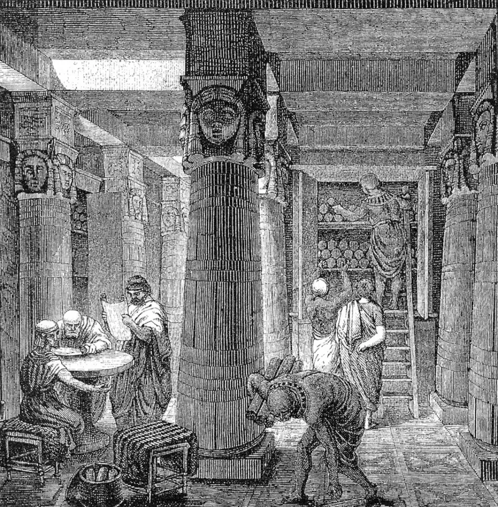
Eratosthenes was born around 276 BC in Cyrene, an ancient Greek colony on the coast of what is now Libya. He studied in Athens before being summoned to Alexandria by King Ptolemy III, where he eventually became the chief librarian of the legendary Library of Alexandria.
His colleagues included some of the most brilliant minds of the ancient world: Archimedes, Aristarchus of Samos, and Apollonius of Perga. Yet Eratosthenes himself earned the nickname “Beta” because, according to his critics, he came second in every field of study he pursued. Others more generously called him “Pentathlos,” comparing him to an athlete who competed in five different events rather than mastering just one.
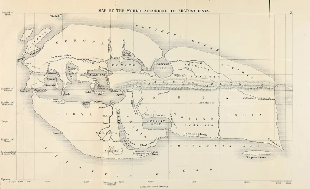
This polymath wrote on geography, mathematics, philosophy, poetry, literary criticism, and astronomy. He invented the sieve of Eratosthenes for finding prime numbers and created one of the first systematic maps of the known world using lines of latitude and longitude.
But his measurement of the Earth’s circumference stands as his most enduring achievement.
The Problem: How Big Is the Earth?
By the third century BC, educated Greeks already accepted that the Earth was spherical. Aristotle had provided compelling arguments for this shape, including the observation that during lunar eclipses, the Earth always casts a circular shadow on the Moon, regardless of the angle.
But knowing the Earth is round and knowing how big it is are two very different things.
Before Eratosthenes, estimates varied wildly. Aristotle mentioned that “the mathematicians” had calculated a circumference of 400,000 stades (the stade being the standard Greek unit of distance). Archimedes referenced a figure of 300,000 stades that was circulating in his day. These were educated guesses at best, and we have no surviving record of how they were derived.
Eratosthenes would change that by developing a method that was both elegant in its simplicity and rigorous in its geometry.
The Key Observation: A Well in Syene
The story begins with a piece of geographical lore that Eratosthenes either observed himself or found documented in the Library of Alexandria.
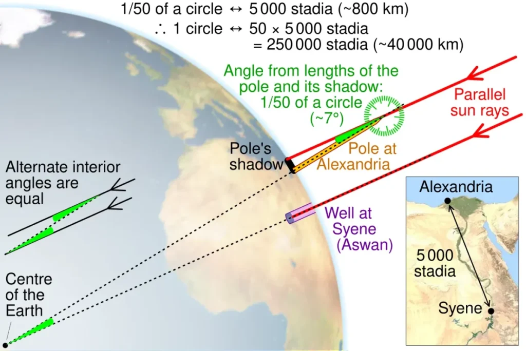
In the city of Syene (modern Aswan, Egypt), there was a deep well. On one specific day each year, at noon on the summer solstice, sunlight illuminated the entire bottom of this well. The Sun was directly overhead, casting no shadow whatsoever.
This was not the case in Alexandria, some 800 kilometers to the north. On that same day, at that same moment, vertical objects in Alexandria still cast shadows. The Sun was not directly overhead there.
Why?
Because the Earth is curved.
If the Earth were flat, the Sun would appear at the same angle everywhere at the same moment. But on a sphere, different locations have different relationships to the Sun at any given instant.
Eratosthenes realized that this difference in shadow angles between two cities contained the key to measuring the entire planet.
The Geometry of the Measurement
Here is where the genius of the method becomes clear.
Eratosthenes made several foundational assumptions:
First, he assumed that the Sun is very far away. So far, in fact, that rays of sunlight reaching different parts of the Earth can be treated as essentially parallel to each other. This is a reasonable approximation. The Sun is roughly 150 million kilometers from Earth, so light rays arriving at Alexandria and Syene are nearly parallel for all practical purposes.
Second, he assumed that Syene lay directly on the Tropic of Cancer, meaning the Sun would be exactly overhead at noon on the summer solstice. This was close to true. Syene is located at about 24°05′ North latitude, while the Tropic of Cancer was at approximately 23°44′ in 240 BC due to the gradual shift in Earth’s axial tilt over time.
Third, he assumed that Alexandria and Syene lay on the same meridian, meaning they were directly north and south of each other. This was slightly inaccurate. Alexandria is at about 29°54′ East longitude, while Syene is at 32°54′ East, a difference of roughly 3 degrees. But for the purposes of his calculation, this error partially cancelled out with other factors.
Now for the measurement itself.
At noon on the summer solstice in Alexandria, Eratosthenes used a gnomon, a vertical rod or pole, to measure the angle of the Sun. The gnomon cast a shadow, and by measuring the relationship between the height of the gnomon and the length of its shadow, he could calculate the angle at which sunlight was striking the ground.
He found this angle to be 1/50th of a complete circle, or 7.2 degrees.
The Calculation
Think about what this 7.2 degree measurement actually represents.
At Syene, the Sun is directly overhead, meaning light rays strike perpendicular to the ground. At Alexandria, the Sun is 7.2 degrees away from directly overhead.
If you extend imaginary lines from each city down to the center of the Earth, those lines would meet at an angle. And here is the critical insight: that angle at the center of the Earth equals the angle of the Sun’s deviation from overhead at Alexandria.
Why? Because the Sun’s rays are parallel. When parallel lines cross a transversal (the radius from Alexandria to Earth’s center), alternate interior angles are equal. This is basic geometry from Euclid’s Elements.
So the arc along the Earth’s surface from Syene to Alexandria represents 7.2 degrees of the total 360 degree circle of the Earth.
Expressed as a fraction: 7.2/360 = 1/50
This means the distance from Syene to Alexandria equals 1/50th of the Earth’s total circumference.
Eratosthenes knew the distance between the two cities to be 5,000 stades. Where did this number come from? Most scholars believe it derived from Egyptian cadastral surveys, records kept by royal surveyors who measured distances along the Nile for administrative and taxation purposes. The Latin writer Martianus Capella mentions that “per mensores regios Ptolemaei” (by the royal surveyors of Ptolemy) such distances were recorded.
With this distance established, the calculation becomes straightforward:
Circumference = 5,000 stades × 50 = 250,000 stades
Converting to Modern Units
Here is where things get complicated, because we do not know exactly how long Eratosthenes’ stade was.
The stade varied from region to region in the ancient world. In fact, this is one of the great ongoing debates among historians of ancient science.
The most widely accepted estimate comes from the philologist Friedrich Hultsch, who in 1882 identified a passage in Pliny the Elder equating 40 stades to one Egyptian schoenus. Taking a schoenus as 12,000 Egyptian cubits, and using archaeological evidence that places the cubit at about 0.525 meters, Hultsch calculated Eratosthenes’ stade at approximately 157.5 meters.
Using this conversion:
250,000 stades × 157.5 meters = 39,375 kilometers
The actual circumference of the Earth through the poles is approximately 40,008 kilometers. NASA’s Earth Fact Sheet lists the equatorial circumference at 40,075 kilometers.
Eratosthenes’ result was within roughly 2% of the true value, an extraordinary achievement given his limited tools.
Built out of a love for history, kept free from distractions.
Spoken Past is an independent project shaped by curiosity, care, and long hours of research. Reader support helps keep it maintained, carefully researched, and open to everyone.
The 250,000 vs 252,000 Stade Mystery
If you research this topic, you will encounter a puzzling discrepancy. The astronomer Cleomedes, writing several centuries after Eratosthenes, gives the result as 250,000 stades. But many other ancient sources, including Strabo, Pliny, Vitruvius, Hero of Alexandria, and Theon of Smyrna, report 252,000 stades instead.
Why the difference?
The traditional explanation holds that 252,000 was a convenient rounding. It divides evenly by 60 (the base of the Babylonian number system used by Greek astronomers) and by 360 (the number of degrees in a circle), yielding exactly 700 stades per degree of latitude.
However, recent scholarship by Christián Carman and James Evans published in the journal Isis in 2015 offers a more sophisticated explanation. They argue that Eratosthenes may have calculated both values intentionally.
The 250,000 stade figure represents a lower limit, calculated under the assumption that the Sun is infinitely far away and its rays are perfectly parallel.
The 252,000 stade figure represents an upper limit, calculated by accounting for the Sun’s actual finite distance from Earth.
Ancient sources preserve Eratosthenes’ estimate for the Earth-Sun distance as 4,080,000 stades. Using this solar distance and applying the law of sines, the calculation yields approximately 252,476 stades, which rounds naturally to 252,000.
This interpretation suggests that Eratosthenes understood his measurement provided a range rather than a single precise value, demonstrating a level of mathematical sophistication that earlier historians may have underestimated.
The Instrument: Gnomon or Skaphe?
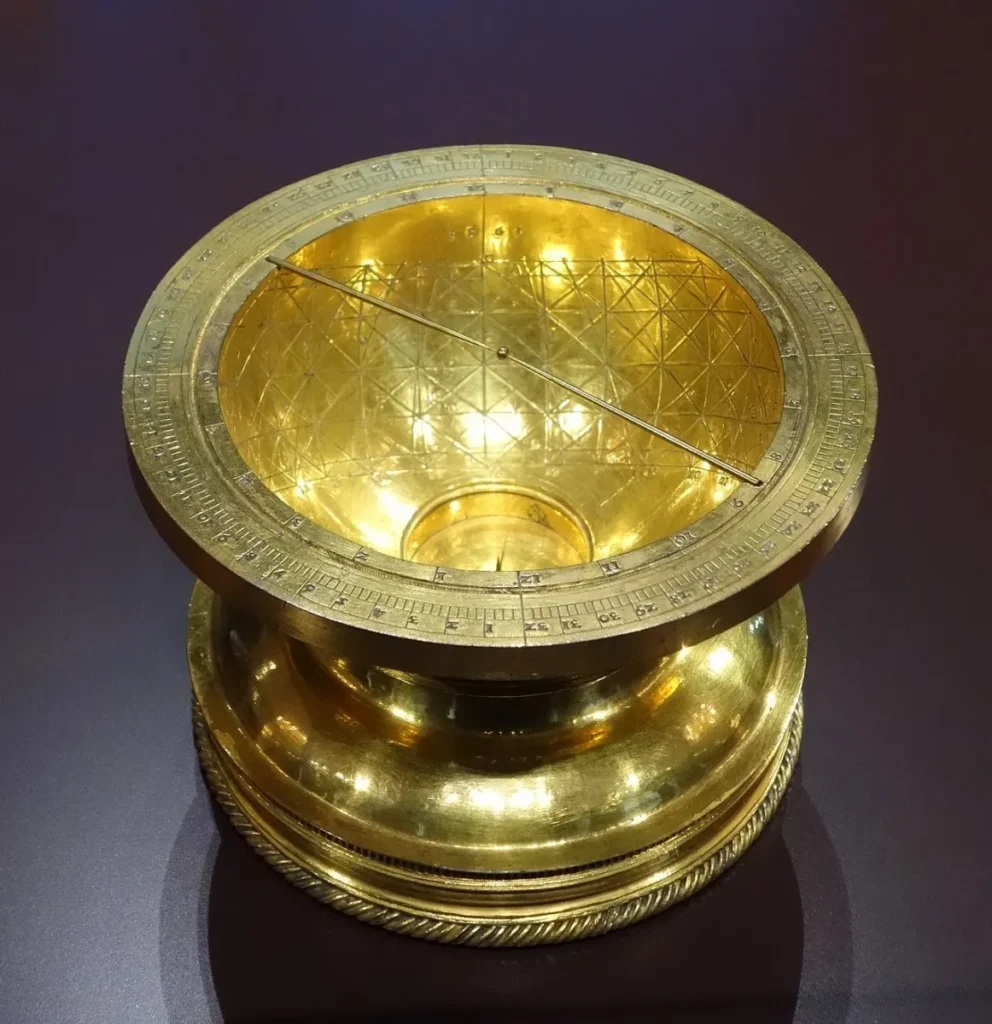
Cleomedes tells us that Eratosthenes used a sundial with a bowl, which likely refers to a skaphe. This instrument, traditionally attributed to Aristarchus of Samos, consisted of a hemispherical bowl with a vertical rod (gnomon) mounted at its center.
When the Sun illuminated the gnomon, it cast a shadow on the curved inner surface of the bowl. Because the bowl’s interior was marked with graduated lines, the shadow’s position could be read directly as an angle rather than requiring a separate calculation from shadow length.
This was a significant improvement over the basic gnomon, which suffered from a practical problem: the Sun is not a point source of light. It subtends a disc of about half a degree in the sky, which means gnomon shadows have fuzzy edges rather than sharp ones. The skaphe’s angular graduations helped reduce this source of error.
Sources of Error in the Method
Modern analysis has identified several factors that affected the accuracy of Eratosthenes’ measurement.
The assumption that Syene lies exactly on the Tropic of Cancer was not quite correct. In 240 BC, the Tropic was about 21 arcminutes south of Syene. This means the Sun was not perfectly overhead at Syene on the solstice; a gnomon there would have cast a very small shadow.
The assumption that Alexandria and Syene share the same meridian introduced additional error. The two cities differ by about 3 degrees in longitude.
The practical difficulties of gnomon measurement, including ensuring perfect verticality and reading the fuzzy edge of a solar shadow, likely introduced errors of several arcminutes.
The distance estimate of 5,000 stades, while probably derived from surveying records, may have been rounded or approximate.
Remarkably, these errors partially cancelled each other out. John Ball, writing in Egypt in the Classical Geographers (1942), demonstrated that the angular errors and distance errors in Eratosthenes’ data happened to work in opposite directions, yielding a final result closer to the truth than any single input would suggest.
This is sometimes called “fortuitous error cancellation,” and it raises interesting questions about how much credit Eratosthenes deserves for his accuracy. Was he simply lucky, or did he understand the uncertainties in his method and choose his inputs carefully?
What Happened to Eratosthenes’ Original Work?
The original treatise in which Eratosthenes described his measurement, titled On the Measurement of the Earth (Περὶ τῆς ἀναμετρήσεως τῆς γῆς in Greek), has been lost for nearly two thousand years.
Everything we know about his method comes from secondary sources, most importantly the account in Cleomedes’ On the Circular Motions of the Celestial Bodies (also known as The Heavens), written sometime around the 2nd century AD, at least 400 years after Eratosthenes’ death.
Hero of Alexandria explicitly mentions the title of Eratosthenes’ lost work and notes that he “worked rather more carefully than others” on this problem. This suggests that Eratosthenes’ original treatise contained more detail and justification than the simplified version Cleomedes presents.
We know from various ancient sources that Eratosthenes’ work also addressed the obliquity of the ecliptic (Earth’s axial tilt), the distances to the Sun and Moon, and the geography of the known world. The measurement of the Earth was likely part of a larger astronomical and geographical program.
The Legacy: From Alexandria to the Space Age
The American Physical Society notes that Eratosthenes’ method remained the basic approach for measuring the Earth for more than two millennia. Even the famous geodetic surveys of the 17th, 18th, and 19th centuries, which used more sophisticated instruments and covered much greater distances, relied on essentially the same geometric principle: measure an arc of the Earth’s surface and the corresponding angular difference in celestial observations, then extrapolate to the full circumference.
It was not until the advent of geodetic satellites in the 1960s that fundamentally new methods became available.
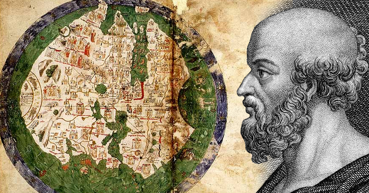
The story also carries a cautionary historical note. A later geographer, Posidonius, attempted his own measurement using observations of the star Canopus rather than the Sun. His result of 180,000 stades was significantly smaller than Eratosthenes’ value and represented a substantial underestimate of Earth’s true size.
This smaller figure was adopted by Claudius Ptolemy in his influential Geography and remained the standard reference for over a thousand years. Some historians have argued that when Columbus set sail in 1492, he was relying on Ptolemy’s inherited underestimate. Had Columbus known the true size of the Earth, he might never have believed that sailing west to reach Asia was feasible with the ships and provisions available to him.
The Man Behind the Measurement
Eratosthenes lived into his eighties, a remarkable lifespan for the ancient world. According to the Suda, a Byzantine encyclopedia compiled in the 10th century AD, he contracted ophthalmia as he aged and gradually lost his sight.
For a man whose entire life had been devoted to observing, reading, and measuring the world around him, blindness proved unbearable. Unable to read the scrolls in his beloved Library, unable to observe the celestial phenomena he had spent decades studying, Eratosthenes chose to end his life by voluntary starvation.
It is a melancholy end for someone whose intellectual curiosity had once spanned the entire planet. But his method survives, taught in classrooms around the world, a testament to what human ingenuity can achieve with nothing more than careful observation, clear thinking, and a stick in the ground casting its shadow in the Egyptian sun.
The measurement of the Earth by Eratosthenes represents one of those rare moments when a single elegant idea opens a door to understanding on a planetary scale. His work laid the foundation for geography as a mathematical science, established the principle that careful local observations can reveal truths about the cosmos as a whole, and demonstrated that the universe is knowable to those who approach it with discipline and imagination.